Investigation · Scientific and technical investigation
The Integration of Geospatial Analysis in Location-Based Investigations
Where things happen is often as revealing as what happens. This article explains how investigators use geospatial analysis, from hot spot mapping and geographic profiling to phone location data and image geolocation, the accuracy limits of location data, and how to present maps fairly.
Every event happens somewhere, and location often holds the key to an investigation. The places where crimes cluster, the movements of a phone before and after an incident, the location shown in a photograph, or the distance between a suspect's home and a series of offences can all help establish what happened and who was involved. Geospatial analysis is the set of methods for collecting, mapping and analysing location data. This article explains how it contributes to investigations, its main methods, and the limits investigators must respect.
Foundations
The idea that mapping reveals patterns is old. In 1854, John Snow mapped deaths from cholera in London and showed that they clustered around a water pump on Broad Street, supporting his theory that cholera spread through contaminated water (Snow, 1855). Geography's "first law", as stated by Tobler (1970), holds that everything is related to everything else, but near things are more related than distant things, a principle that underlies much spatial analysis.
Criminology adds evidence that crime is highly concentrated in place. Sherman et al. (1989) found that a small proportion of addresses in Minneapolis accounted for a large share of calls to the police, and Weisburd (2015) showed across many cities that a small percentage of street segments consistently account for about half of crime. Environmental criminology explains these patterns through the routine movements of offenders and targets (Brantingham & Brantingham, 1981).
Main methods
Hot spot mapping. Mapping incidents and identifying concentrations helps investigators and managers decide where to focus. Eck et al. (2005) and Chainey and Ratcliffe (2005) describe methods such as kernel density estimation and statistical tests for clustering, and caution that the choice of method and settings affects what the map appears to show.
Geographic profiling. For a series of crimes linked to one offender, geographic profiling estimates the area where the offender is most likely to live or be based, helping to prioritise suspects and searches (Rossmo, 2000). It relies on research showing that offenders tend to offend close to home but not immediately next to it.
Case linkage by distance. The distance between offences is often a strong indicator that they were committed by the same person. Bennell and Canter (2002) found that distance outperformed other behavioural features in linking commercial burglaries.
Phone and device location. Phones generate location data from satellite positioning, Wi-Fi networks and cell sites. These records can place a device near a scene or show a route. In Carpenter v. United States (2018), the United States Supreme Court held that obtaining historical cell-site records generally requires a warrant, recognising how much they reveal.
Image geolocation. Open-source investigators identify where photographs and videos were taken by matching landscape features, buildings, shadows and signs to satellite and street-level imagery. Higgins (2021) describes how such methods were used to trace the route of the missile launcher involved in the downing of Malaysia Airlines Flight MH17.
Accuracy and its limits
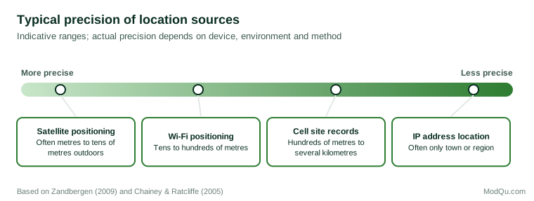
Location data are never exact. Zandbergen (2009) compared the accuracy of satellite, Wi-Fi and cellular positioning on smartphones and found large differences, with cellular positioning far less precise than satellite positioning. A cell site record indicates which mast handled a call, and the area that mast serves may cover many square kilometres. Treating such records as showing a precise location has contributed to errors in court.
Maps can also mislead through the way areas are drawn. The modifiable areal unit problem means that results can change depending on the size and shape of the areas used to aggregate data (Openshaw, 1984). A cluster that appears with one set of boundaries may disappear with another. Analysts should therefore test whether a pattern holds when the areas or settings are changed before relying on it.
Good practice
Geospatial evidence is strongest when several independent sources agree. A phone's location history, a vehicle's telematics, payment card transactions and camera footage each have different weaknesses, so agreement between them is more persuasive than any one alone, and disagreement is a signal to look more closely. Investigators should record the source and precision of each location, show uncertainty on maps rather than single points, test whether apparent clusters could arise by chance, avoid choosing map settings that exaggerate a pattern, corroborate location evidence with independent sources, and obtain proper legal authority before acquiring location data. Because location histories reveal homes, workplaces, relationships and routines, they should be limited to the periods and people the investigation needs, and stored securely.
A short example
The following hypothetical case shows these practices. An insurer investigates a claim that a vehicle was stolen from outside the claimant's home at 2 a.m. The claimant's phone records show a cell site serving the home area at that time, which the claimant cites as proof they were home. The analyst notes that the cell site covers several kilometres, including a car park where the vehicle was later found burned out. The vehicle's own telematics data, precise to a few metres, show that it was driven from the home to the car park at 1.40 a.m. with no sign of forced entry, and a nearby camera records the claimant's partner arriving there. The analyst's report shows the precision of each source on the map, and the finding rests on the precise data rather than the cell site record.
Conclusion
Geospatial analysis helps investigators see where events cluster, link related incidents, prioritise suspects, and establish where people and devices were. Its value depends on understanding the precision of location data and the effect of mapping choices. Investigators who record sources and uncertainty, test patterns and corroborate locations can make maps a reliable part of their evidence.
References
Bennell, C., & Canter, D. V. (2002). Linking commercial burglaries by modus operandi: Tests using regression and ROC analysis. Science & Justice, 42(3), 153–164. https://doi.org/10.1016/S1355-0306(02)71820-0
Brantingham, P. J., & Brantingham, P. L. (Eds.). (1981). Environmental criminology. Sage.
Carpenter v. United States, 585 U.S. 296 (2018).
Chainey, S., & Ratcliffe, J. (2005). GIS and crime mapping. Wiley.
Eck, J. E., Chainey, S., Cameron, J. G., Leitner, M., & Wilson, R. E. (2005). Mapping crime: Understanding hot spots. National Institute of Justice.
Higgins, E. (2021). We are Bellingcat: An intelligence agency for the people. Bloomsbury.
Openshaw, S. (1984). The modifiable areal unit problem. Geo Books.
Rossmo, D. K. (2000). Geographic profiling. CRC Press.
Sherman, L. W., Gartin, P. R., & Buerger, M. E. (1989). Hot spots of predatory crime: Routine activities and the criminology of place. Criminology, 27(1), 27–56. https://doi.org/10.1111/j.1745-9125.1989.tb00862.x
Snow, J. (1855). On the mode of communication of cholera (2nd ed.). John Churchill.
Tobler, W. R. (1970). A computer movie simulating urban growth in the Detroit region. Economic Geography, 46(Suppl.), 234–240. https://doi.org/10.2307/143141
Weisburd, D. (2015). The law of crime concentration and the criminology of place. Criminology, 53(2), 133–157. https://doi.org/10.1111/1745-9125.12070
Zandbergen, P. A. (2009). Accuracy of iPhone locations: A comparison of assisted GPS, WiFi and cellular positioning. Transactions in GIS, 13(s1), 5–25. https://doi.org/10.1111/j.1467-9671.2009.01152.x